
The FAA has released its long-awaited Notice of Proposed Rulemaking (NPRM) on Normalising Unmanned Aircraft Systems Beyond Visual Line of Sight (BVLOS) Operations. This marks a pivotal step in the integration of commercial drones into the US National Airspace System (NAS). The proposal blends a risk-based regulatory framework with a strong emphasis on scalable traffic management, bringing the US approach closer to the European model.
In terms of what this means for the drone industry, this framework provides a path towards:
- The routine delivery of packages to homes or businesses in suburban (or even urban) areas via drone
- Agricultural uses of drones including surveying and the application of crop protection products
- Many civic interest, training, testing and recreational applications of uncrewed aircraft
Ultimately, this opens up much of the skies over the US for businesses and individuals. Moving aspects of package delivery and crop protection away from ground-based transport and into autonomous, electrified and airborne vehicles should result in greater levels of safety and vastly reduced emissions – one study referenced by the FAA in the text indicates a 97% reduction in carbon emissions associated with package delivery by drone in rural areas.
The text itself is long – over 700 pages and no explanatory diagrams or pictures. This post therefore constitutes a ‘hot take’ based on our initial reading.
Strategic deconfliction at the core
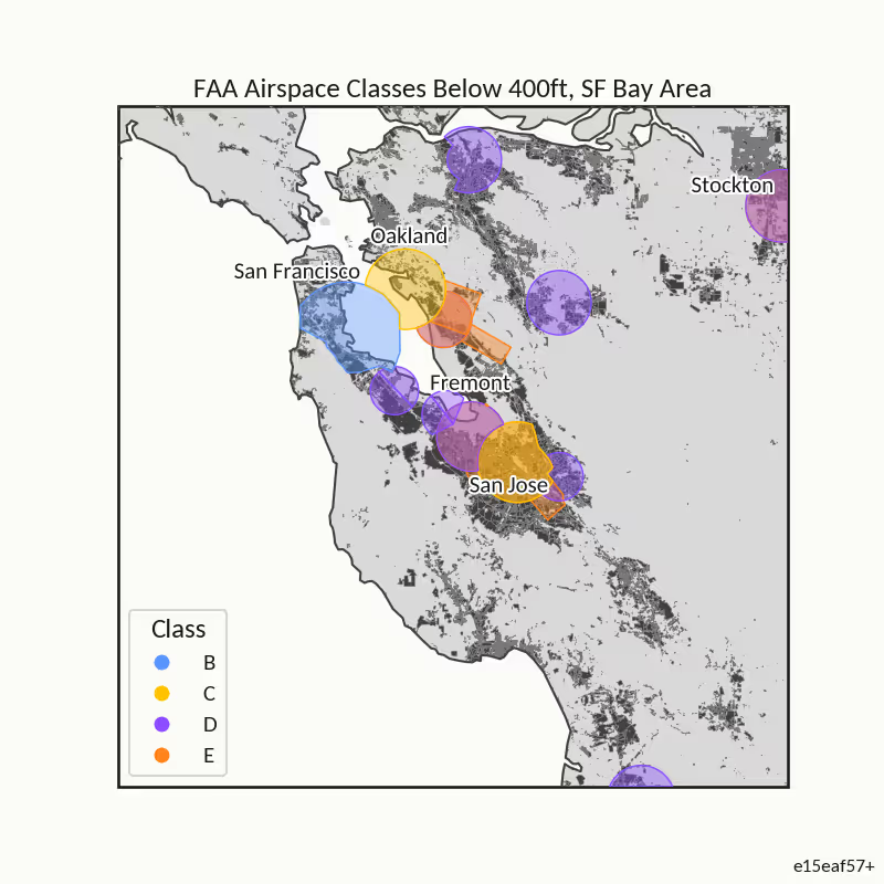
At the heart of the NPRM is strategic deconfliction -the pre-planned separation of aircraft trajectories to avoid conflict. The FAA proposes enabling routine BVLOS flights in controlled airspace at or below 400 ft AGL and over areas with higher population density (category 3 and above) if the operator participates in strategic deconfliction and conformance monitoring.
Fundamental to strategic deconfliction is the use of Automated Data Service Providers (ADSPs) who will provide services to keep BVLOS drones safely separated from each other and from manned aircraft. The FAA would approve and regulate these entities and require the services to conform to industry consensus standards following vetting and testing.
Conformance monitoring, verifying that unmanned aircraft follow their declared flight plans, is described as essential for safety. Without it, the benefits of strategic deconfliction are greatly reduced. However, the FAA also warns that unreliable command and control (C2) links can limit the effectiveness of both measures, meaning they are initially most suitable for dense airspace and controlled zones, rather than rural areas.
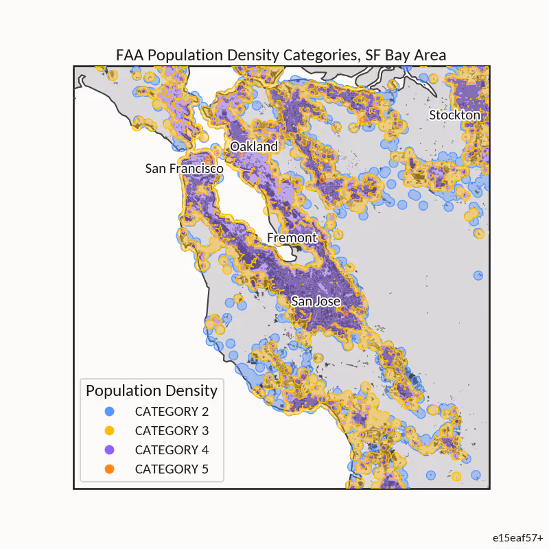
Risk-based regulation in line with EASA
The FAA’s proposal mirrors EASA’s Specific Operations Risk Assessment (SORA) methodology by tailoring mitigations to ground and air risks rather than imposing uniform rules. The NPRM defines five population-density categories, from low-risk rural areas to dense metropolitan centres. Higher categories require progressively more robust mitigations:
- Category 3 and above (Includes suburban and rural areas): Requires strategic deconfliction
- Category 5 (Includes flying over shopping centres, multifamily housing and cities): Requires onboard detect-and-avoid (DAA) for non-cooperative aircraft
Certain high-risk operations—likely similar to SAIL IV and above—would also require UA-to-UA DAA. This framework allows lower-risk operations to proceed without costly technology burdens while ensuring higher-risk scenarios receive additional safeguards.
Detect-and-avoid - the unfinished piece
The NPRM acknowledges that UA-to-UA DAA standards remain unresolved. While RTCA’s Minimum Operational Performance Standards (MOPS) for ACAS sXu provide an algorithmic approach for tactical avoidance, robust, validated methods for detecting non-cooperative drones are still lacking. Until such solutions are standardised, high-risk BVLOS operations may require alternative mitigations or remain restricted.
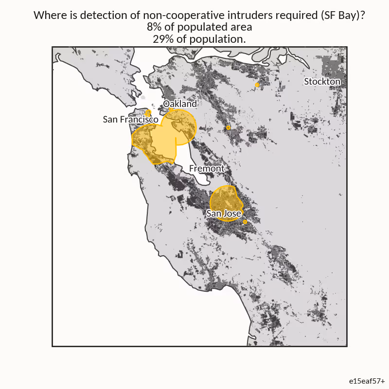
Looking at the map above, it is clear that drone deliveries to households will start in rural and suburban areas, where the economics work well and where the ground risk is low. Across the US, the requirement for detecting non-cooperative aircraft results in rules that apply to about 4% of the populated area, which is roughly 17% of the population. DAA will therefore likely be required on mid-mile deliveries and logistics rather than last-mile deliveries, at least to begin with.
Rethinking right-of-way and electronic conspicuity
The FAA proposes prohibiting ADS-B Out and active transponder use on unmanned aircraft, citing concerns about overloading systems designed for manned aviation. Instead, it is considering a new low-cost, portable Electronic Conspicuity (EC) device for manned aircraft, potentially formalised through a new Technical Standard Order (TSO).
Right-of-way rules are clarified: UA must yield to cooperative aircraft, though Part 108 UA may, in some cases, have priority over non-cooperative aircraft. In shielded operations—close to structures or terrain—UA may not need to yield at all. Regardless, maintaining a safe separation distance remains mandatory, achieved either through DAA or strategic deconfliction.
Data-driven safety rationale
The NPRM cites MITRE research quantifying collision risk in uncontrolled Class G airspace without mitigations: approximately one collision per 10,000 flight hours in dense airspace, compared to one in a million hours in sparsely used areas. This evidence underpins the FAA’s decision to scale mitigations according to risk rather than mandate uniform requirements.
Key industry implications
For UAS technology developers, operators, and suppliers, the NPRM signals both opportunities and challenges:
- Technology Development – UA-to-UA DAA remains an unsolved technical challenge, with high regulatory importance and commercial potential.
- Strategic Deconfliction Platforms – Integrated planning and conformance monitoring tools will be critical for scaling BVLOS operations in higher-risk airspace.
The proposal also invites innovation in EC devices and offers flexibility for lower-risk operations, potentially reducing barriers to entry in some market segments.
Shaping the final rule
The FAA is actively seeking comment on critical areas, including:
- How to implement effective DAA for non-cooperative aircraft below 500 ft AGL.
- The operational feasibility of strategic deconfliction in environments with unreliable C2 links.
- Technical specifications and deployment strategies for the proposed EC device.
These open questions mean the industry has a clear window to influence the outcome, ensuring the final rules support both safety and operational viability.
Conclusion
The FAA’s BVLOS NPRM is a pragmatic move toward normalising unmanned aircraft integration into the NAS. By aligning more closely with international risk-based models and combining strategic deconfliction with targeted equipage requirements, it paves the way for scalable BVLOS operations—while leaving room for innovation in key technical areas.
For industry stakeholders, this is not just a regulatory update; it’s a call to help shape the next era of drone operations in the United States. In terms of what will be happening over our heads in the near future, this regulation is arguably as significant as the certification of the helicopter in the 1940s. With the regulations in place and a route to compliance taking shape, the drone industry is about to accelerate out of the starting blocks – disruption is coming to multiple industries as a result. Interesting times.
Find more information on this useful BVLOS factsheet.
If you'd like to find out more about the work we are doing in this area and UAV satcoms please get in touch.

.avif)